Online data sources |
  
|
Online data sources |
|
Background Maps - Online tab
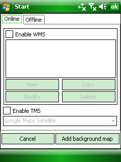
[ ] Enable WMS: Allows to add your own Open Geospatial Consortium standard Web Map Service data sources for access to any data published on a WMS server. The built-in WMS client supports the WMS server served map image data in bitmap format, e.g. PNG, GIF or JPEG. WMTS data sources are also supported here.
A Web Map Service (WMS) is a standard protocol for serving georeferenced map images over the Internet that are generated by a map server using data from a GIS database. The specification was developed and first published by the Open Geospatial Consortium in 1999.
WMS specifies a number of different request types, two of which are required by any WMS server:
●GetCapabilities - returns parameters about the WMS (such as map image format and WMS version compatibility) and the available layers (map bounding box, coordinate reference systems, URI of the data and whether the layer is mostly opaque or not)
●GetMap - returns a map image. Parameters include: width and height of the map, coordinate reference system, rendering style, image format
Request types that WMS providers may optionally support include:
●GetFeatureInfo - if a layer is marked as 'queryable' then you can request data about a coordinate of the map image.
●DescribeLayer
●GetLegendGraphic - return an image of the map's legend image, giving a visual guide to map elements
WMS list: displays the previously defined WMS servers listed below each other. Inactive if the Enable WMS option not checked.
Adding a WMS layer to the map view: you can quickly add a WMS server data source to the map view as Background Map layer by selecting a WMS server list item here and then tap/click on the Add background map button.
Removing a WMS layer from the map view: uncheck the check box before "Enable WMS"
New - Opens the WMS Server Management panel to define a new server
Copy - Copies the selected WMS source as a new source (i.e.) to define a new layer set from the available data layers on the WMS Server Management panel
Modify - Opens the WMS Server Management panel to modify the parameters of the selected WMS source
Delete - Removes the selected WMS source from the list
[ ] Enable TMS - Allows to use a built-in Tile Map Service source as a background map layer
Tile Map Service or TMS, is a specification for storing and retrieving cartographic data, developed by the Open Source Geospatial Foundation. The definition generally requires a URI structure which attempts to fulfill REST principles. The TMS protocol fills a gap between the simplistic standard used by OpenStreetMap and the complexity of the Web Map Service standard, providing simple urls to tiles while also supporting alternate spatial referencing system.
●Google Maps Satellite
●Google Maps Topographic
●Google Maps Road
●Bing Maps Satellite
●Bing Maps Road
●Open Street Maps
●Nokia Maps Satellite
●Nokia Maps Road
●Nokia Maps Transit
●CloudMade Maps
●Open Sea Map
●Open Street Maps Polska
●Freemap Slovakia Road
●New Zealand Topographic Maps
Adding a TMS layer to the map view: select a TMS server option in the drop-down list and then tap/click on the Add background map button
Removing a TMS layer from the map view: uncheck the check box before "Enable TMS"
Cancel - Closes the panel
Add background map - Adds the selected WMS or TMS server source to the current map view as a background map layer