Printing maps and reports |
  
|
Printing maps and reports |
|
Prints the current Map. This menu item is available only in the Desktop version.
The Printing available in the Desktop version only. You can print the map view, attributes and an area measuring report through the default Print Setup and by using three special paneles (one for the map view, attributes and for the area measuring report).
Print Setup panel
Use the Print Setup panel to select the printer, page orientation, and paper size you want to use to print the report/map view. If you do not select a printer, the program will print to the Windows default printer.
This panel appears when you click on the ![]() Print button in the menu bar/toolbar, OK button in the Print Report panel, and click on OK button in the Printing Area Report panel.
Print button in the menu bar/toolbar, OK button in the Print Report panel, and click on OK button in the Printing Area Report panel.
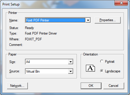
Printer
Name: Find the name of the printer to which you can send reports/map views in the Name list.
Properties - Click the Properties button to bring up the Properties panel for the selected printer.
Paper
Size: Use the Size list to select from a variety of paper- or envelope-size options.
Source: Use the Source list to select from a variety of feed or paper source options.
Orientation
Portrait: Select the Portrait option to print your report in a standard-letter orientation.
Landscape: Select the Landscape option to print your report in landscape orientation.
Network: Click the Network button to connect to a network printer.