The Custom Projection panel |
  
|
The Custom Projection panel |
|
The Custom projection panel consists of the following controls to customize the selected projection:
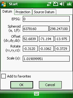
Datum tab
Add favorites: adds the selected projection to the Favorites
Datum tab:
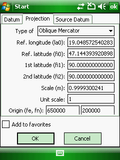
Type of: Select a projection type (algorithm).
●Geographic
●Stereographic projection
●Mercator
●Transverse Mercator
●Oblique Mercator
●Hotine Oblique Mercator
●Lambert conformal conic
●Hungarian stereographic
●Hungarian cylindrical
●Hungarian Unified projection
●Swiss cylindrical
●Romania TransDat 2009
Projection tab:
Projection tab
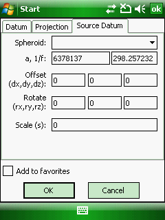
Spheroid (a, 1/f): Semi-major Axis, Inverse Flattening ratio.
Offset (dx, dy, dz): Offset DX, DY, DZ to WGS84 parameters in meter.
Rotate (rx, ry, rz): Rotate RX, RY, RZ to WGS84 parameters in arc seconds.
Scale (s): Scale Factor in ppm.
Ref. longitude (la0): Origin Longitude in degree.
Ref. latitude (fi0): Origin Latitude in degree.
1st latitude (fi1): First Latitude in degree.
2nd latitude (fi2): Second latitude in degree.
Scale (m): Scale Factor.
Unit scale: Unit scale value (indicates the unit value in meter).
Origin (fe, fn): False easting, False nothing.
![]() The modified Datum and Projection parameters are stored in in DigiTerra Explorer Map (.EXP) / DigiTerra Map Pack (.DMP) files and in the user.db3 file
The modified Datum and Projection parameters are stored in in DigiTerra Explorer Map (.EXP) / DigiTerra Map Pack (.DMP) files and in the user.db3 file
On the Source Datum tab you can define the GPS Datum when using Real Time Corrections with different Source Datum (not WGS 84)
Source Datum tab