The Record panel |
  
|
The Record panel |
|
The Record panel contains the following controls:
Record panel (Mobile and Desktop)
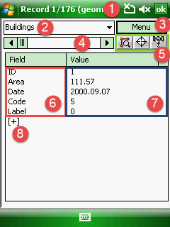
1 - Header: "Record 1/176" means that you are viewing the 1st record of the total 176 records. "(geom)" means that the current attribute table 176 features with vector geometry
2 - Lists all attribute tables of the vector feature layers you are using in the map project
3 - Menu button: opens the menu
4 - Horizontal scroll bar:
oDrag the scroll box to move forward or backward in the attribute table
oClick the scroll arrows to move forward or backward in the attribute table
5 - Buttons:
o![]() - displays the linked feature of the selected record on the map
- displays the linked feature of the selected record on the map
o![]() - activates the Target tool and sets the Target position to the selected feature of the record
- activates the Target tool and sets the Target position to the selected feature of the record
o![]() - activates the GNSS resurveying function
- activates the GNSS resurveying function
6 - Field names: Lists all data field from the attribute table in the left column. Tap on the data field name to open and edit the field definitions on the Data field panel
7 - Attribute values: Lists all values to the current record in the right column. Tap on the value to edit as:
oOpening the Attribute editor to edit data
oOpening the Enum panel to use a code from the code dictionary
8 - [+] Opens the New data field panel to create a new data field
ok / x - Approves and saves all changes you made then closes the panel and proceeds to save the code dictionary if you defined codes to a data field the very first time