Generate TIN |
  
|
Generate TIN |
|
![]() Generate TIN
Generate TIN
Opens the Generate TIN panel to create a TIN vector file from vector feature layer or from the layer's attribute fields.
Generate TIN panel
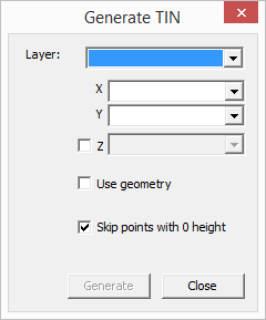
Layer - List the available vector layers and attribute tables from the current map view. Select the layer from the drop-down list that contains x, y, z data as geometry or attribute data.
X - List the attribute fields of the selected layer. Select a data field that stores the X coordinates.
Y - List the attribute fields of the selected layer. Select a data field that stores the Y coordinates.
Z - List the attribute fields of the selected layer. Select a data field that stores the Z coordinates (heights values).
[ ] Use geometry - The TIN generator uses only the geometry to create the TIN file.
[x] Skip points with 0 height - The TIN generator skips the zero heights from the geometry to create the TIN file.