The New layer panel accessible through the ![]() New Layer command once you have selected the vector file name, file format and PATH on the Create layer file panel.
New Layer command once you have selected the vector file name, file format and PATH on the Create layer file panel.
New layer panel contains the following controls:
The New layer panel
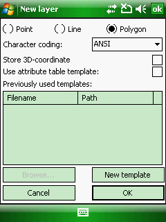
Type of geometry: Select a feature type for the new layer with a radio button
Default feature type: Polygon
![]() The default feature type can be easily modifiable by selecting a different feature type on the New layer panel.
The default feature type can be easily modifiable by selecting a different feature type on the New layer panel.
●Point: the new layer will be a point feature layer
●Line: the new layer will be a line feature layer
●Polygon: the new layer will be a polygon feature layer
Character coding: Select a character coding method you wish to use to the attribute table of the template
Default character coding: ANSI
●ANSI
●UTF-8 (available since version 6)
●UNICODE (available since version 6)
![]() In case of using ESRI Shape file (.SHP) the selected code page will be stored in .CPG format. In case of using MAP - DigiTerra vector layer format, the code page can be stored in the TAB - DigiTerra file.
In case of using ESRI Shape file (.SHP) the selected code page will be stored in .CPG format. In case of using MAP - DigiTerra vector layer format, the code page can be stored in the TAB - DigiTerra file.
Store 3D coordinate: Enables to store 3D coordinates in the new layer when capturing a feature with GPS on the GNSS Survey panel
![]() Please note that the Z coordinate can only be stored in DXF - AutoDesk, SHP - ESRI Shape and MAP - DigiTerra file formats
Please note that the Z coordinate can only be stored in DXF - AutoDesk, SHP - ESRI Shape and MAP - DigiTerra file formats
Use attribute table template: Enables to use attribute table templates for the created new layer. Default option is unchecked.
Previously used templates: Lists the previously used attribute table templates
Browse... - Opens the Select template file panel to select an existing attribute table template. This button active only when the "Use attribute table template" option checked. The template PATH described in the Select template topic.
New template - Opens the New template file panel to create a new attribute table template to the template PATH
Cancel - Closes the New layer panel
OK - Closes the New layer panel and then stores the new vector layer in the defined path, file format, feature type, character coding, 3D storing option and creates the attribute table based on the selected attribute table template.