The Select projection panel contains the following controls:
The Select projection dialog displays the selectable projections in a tree view menu. Region > Country > Grid > Projection.
The Select projection panel: Region > Country > Grid > Projection
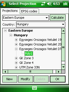
Projections tab:
New - Opens the New projection panel to create a new projection
Modify - Opens the Custom projection panel to customize the selected projection
Delete - Deletes the selected projection
Calculate - Opens the Calculate panel to calculate differences between two projections to one reference point in WGS84
OK - Closes the panel
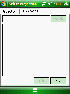
EPSG tab:
Search box: Enter the EPSG code you want you use as the projection of the map view
Search - Searches the EPSG code and lists the results in the list below
Result list: Lists the results. You can select an EPSG code here and use it as the projection of the map view.
Modify - Opens the Custom projection panel to customize the selected projection
OK - Closes the panel
 Please, note that these projections below cannot be modified or deleted:
Romania
- RS70 DT -> Poly2
- TransDatRo-1930 -> ETRS89
- TransDatRo-1970 -> ETRS89
Hungary
- Egyseges Orszagos Vetulet DT -> Poly1
United Kingdom
- British National Grid DT ->Poly3
- OSTN02+OSGM02 -> ETRS89
- Northern Irish Grid DT -> Poly5
Ireland
- Irish National Grid DT -> Poly4