The Tree surveying extension is not part of the core DigiTerra Explorer. It is an additional software module for surveying trees with GPS/GNSS receiver and Lasertech Trupulse 360B. It can be accessed in the menu bar: Tools > ![]() Tree surveying and in the toolbar with the
Tree surveying and in the toolbar with the ![]() Tree surveying button.
Tree surveying button.
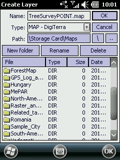
Opens the Create Layer File panel to enter the name of the new point feature layer that stores the surveyed trees. Opens the Tree surveying panel if you have an existing tree surveying layer.
Create Layer Files panel
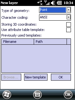
New layer Files panel
Tree Surveying panel
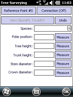
Reference Point #0 - Tap on this button to define your standing point on the field with the Add new reference point panel. "#0" means that your standing point is not yet defined.
Reference Point #1 - "#1" means that you are on the first standing point. Tap on this button again if you want to measure more trees from an other standing point.
Add new reference point panel

GPS - takes over the Easting, Northing coordinates of the current GPS position to define the standing point at the current GPS location.
Ok - saves the standing point and then closes the panel
Cancel - closes the panel without saving the standing point
Reference point symbol on the map view
![]()
Connection (Off) - Opens the Settings > Rangefinder tab to connect DigiTerra Explorer to the Rangefinder. "Off" means the software not connected to the Rangefinder.
![]() Remember to enable the Trupulse 360B for Bluetooth operation before start working with the Tree surveying extension. Please continue with the following help tutorial about "Enabling Bluetooth".
Remember to enable the Trupulse 360B for Bluetooth operation before start working with the Tree surveying extension. Please continue with the following help tutorial about "Enabling Bluetooth".
Connection (On) - Opens the Settings > Rangefinder tab to modify connection settings with the Rangefinder. "On" means the software connected to the Rangefinder.
Species: Select an existing tree species or enter a new species and use it later. The Species drop-down list automatically stores the entered tree species in the TreeSurvey.cdt code dictionary. This code dictionary can also be edited manually in your preferred text editor.
Path:
Desktop version: |
$DOCUMENTS\DigiTerra Explorer\Maps\TreeSurvey.cdt |
Mobile version: |
$SDCARD\Maps\TreeSurvey.cdt |
Polar position: Displays the measured values. You can also enter the values in [degree, meter].
Measure - Displays the following message box: "DigiTerra Explorer controls TruPulse 360B to measure an Azimuth (AZ) and Horizontal Distance (HD). Look through the eyepiece and use the crosshair to aim to the target. Press-and-hold the FIRE button." The message box closes automatically once your finished the measurement.
Tree height: Displays the measured value. You can also enter the values in [meter].
Measure - Displays the following message box: "DigiTerra Explorer controls TruPulse 360B to measure the Tree height with the Height Routine. Height Measurements involve a simple routine that prompts you to take 3 shots to the target: HD, INC base (or top), and INC top (or base). The TruPulse uses these results to calculate the height of the target." The message box closes automatically once your finished the measurement.
Trunk height: Displays the measured value. You can also enter the values in [meter].
Measure - Displays the following message box: "DigiTerra Explorer controls TruPulse 360B to measure the Trunk height with the Height Routine. Height Measurements involve a simple routine that prompts you to take 3 shots to the target: HD, INC base (or top), and INC top (or base). The TruPulse uses these results to calculate the height of the target.
" The message box closes automatically once your finished the measurement.
Stem diameter: Displays the measured value. You can also enter the values in [meter].
Measure - Displays the following message box: "DigiTerra Explorer controls TruPulse 360B to measure the Stem diameter with the Missing Line Routine. The Missing Line Routine calculates distances and angles to describe the relationship between two extremities of the stem. The simple routine prompts you to take two shots to targets: "Shot 1” and “Shot 2”." The message box closes automatically once your finished the measurement.
Crown diameter: Displays the measured value. You can also enter the values in [meter].
Measure - Displays the following message box: "DigiTerra Explorer controls TruPulse 360B to measure the Crown diameter with the Missing Line Routine. The Missing Line Routine calculates distances and angles to describe the relationship between two extremities of the crown. The simple routine prompts you to take two shots to targets: "Shot 1” and “Shot 2”." The message box closes automatically once your finished the measurement.
![]() The measurement can be repeatable by tapping on the Measure button.
The measurement can be repeatable by tapping on the Measure button.
New (Num#0, Total#0) - Displays the currently measured Tree's number and the total number of surveyed trees. Tap on this button to start surveying a new tree.
Undo - Removes the last measurement.
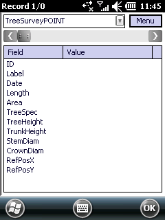
Attribute table structure of the Tree surveying point feature layer