New vertex panel |
  
|
New vertex panel |
|
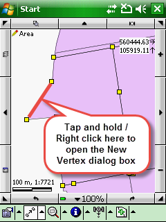
The New vertex panel enables you to add vertex into the selected feature's geometry between two vertices by coordinates and by GPS. It also enables you to split a polyline feature into two separate features. When using it from the context menu of the Query menu > Measuring tools you can add the vertex to the red editing line to measure on the map.
1.From the Editing context menu > Position menu option
2.With the Insert, Remove, Edit vertex editing tools
New vertex panel
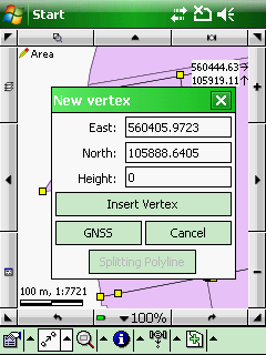
East: Displays the current Easting coordinate of the tapped/clicked position as default. Enables you to enter the new Easting coordinate.
North: Displays the current Northing coordinate of the tapped/clicked position as default. Enables you to enter the new Northing coordinate.
Height: enables you to enter the Height of the new vertex that you can save with the [Insert Vertex] button if the the layer can store 3D-coordinate
Insert Vertex - adds the vertex with the modified coordinates into the selected geometry
GNSS - takes over the Easting, Northing, Height coordinates of the current GNSS position to add a vertex into the geometry at the current GPS position
Cancel - Closes the panel
Splitting Polyline - Splits the polyline geometry at the tapped position between two vertices into two separate features. Disabled when working with point and polygon features. Hidden when you opened the New vertex panel from the Editing context menu.
![]() Height (Z value) can be stored in MAP, SHP, DXF layer file formats. Please also have a look at this tutorial here: http://forum.digiterra.hu/viewtopic.php?f=60&t=302
Height (Z value) can be stored in MAP, SHP, DXF layer file formats. Please also have a look at this tutorial here: http://forum.digiterra.hu/viewtopic.php?f=60&t=302