Save db project |
  
|
Save db project |
|
![]() Save db project
Save db project
Opens the Save db project panel to save the current project into SQLite DB3 geodatabase.
Supported geodatabase: DB3 - SQLite version 3
Save db project panel
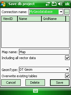
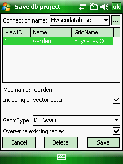
Connection name: Lists the connections in a drop-down list, that can be created on the Database connection dialog box to SQLite DB3 geodatabase files. A connection needs to be selected from the list to display its view(s) in the SQL view list below.
![]() - Opens the Database connection panel to manage connections with geodatabases
- Opens the Database connection panel to manage connections with geodatabases
SQL view list: Lists the SQL views of the geodatabase. Tap on a list item to select an SQL view for updating its content or deletion.
Map name: Enter the name of the SQL view. The default name is "Map" or the name of the original mapping project file name.
Including all vector data: Saves all vector geometry into geodatabase. Checked as default.
GeomType: Select a geometry type if you want to store to the vector geometry in the geodatabase.
●DT Geom: DigiTerra Binary Geometry data field type. Solid, encrypted data field format that can be only read by DigiTerra Explorer 7. Default geometry format.
●WKT: Well-known text (WKT) is a text markup language for representing vector geometry objects on a map, more details: http://en.wikipedia.org/wiki/Well-known_text
●WKB: Well-known binary (WKB). Solid data field format, more details: http://en.wikipedia.org/wiki/Well-known_text#Well-known_binary
Overwrite existing tables: Overwrites existing data tables in the geodatabase when updating a geodatabase. e.g. when adding new features or modifying the thematic classes, labels, etc... Checked as default.
Cancel - Closes the Save db project panel
Delete - Deletes the selected SQL view from the geodatabase
Save - Saves/Updates the map view as an SQL view into the geodatabase
|
Basic |
Advanced |
Professional |
Availability of the "Save db project" command in different editions |
|
|
|