Scale |
  
|
Scale |
|
The Scale panel is used to specify the minimum and the maximum display scales of the layer.
The display scale for the layer's symbols and labels can be specified on the Labels panel. The display scale and the label scale can be specified for the layer's thematic classes on the Class panel.
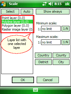
Select: Selects all layers, or clears the selection.
Auto: Sets the scale range of each layer on the basis of its data density.
Show always: Displays the selected layer at all scales.
![]() When added a new layer to the DigiTerra Explorer map the default setting is show layer at all scales.
When added a new layer to the DigiTerra Explorer map the default setting is show layer at all scales.
List: Select layers. Drag: multiple selection. Value in brackets: average occupied area of one geometry in square kilometers.
Selected layer cannot be seen under this scale. 1:N Chooses the current map scale for layer's minimum scale. The default is no limit.
Type the minimum scale at which the layer will be displayed or tap to 1:N choose the current map scale. When it displays the "no limit" value, the layer is always displayed. In other cases, the layer is not displayed when the map scale is larger than the scale specified in this field. For example, if this field is set to 10000, the layer is displayed at a map scale of 1:10001 but not at a map scale of 1:9999.
Selected layer cannot be seen over this scale. 1:N Chooses the current scale for layer's maximum scale. The default is no limit.
Type the maximum scale at which the layer will be displayed or tap to 1:N choose the current map scale. When it displays the "no limit" value, the layer is always displayed. In other cases, the layer is not displayed when the map scale is smaller than the scale specified in this field. For example, if this field is set to 10000, the layer is displayed at a map scale of 1:9999 but not at a map scale of 1:10001.
Country: Set the minimum scale of the selected layer to 1:500 000.
County: Set the maximum scale of the selected layer to 1:1 000 000.
District: Set the maximum scale of the selected layer to 1:500 000.
City: Set the maximum scale of the selected layer to 1:100 000.
![]() The layer's display scale settings can be stored in DigiTerra Explorer Map file (.EXP) or DigiTerra Map Pack file (.DMP) formats.
The layer's display scale settings can be stored in DigiTerra Explorer Map file (.EXP) or DigiTerra Map Pack file (.DMP) formats.