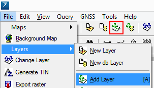
1.This command is accessible in the File menu > Layers sub-menu with the ![]() button and in the toolbar (Desktop version).
button and in the toolbar (Desktop version).
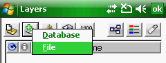
2.O the Layer Manager: tap on the ![]() Append Layer button > and select the File option in the pop-up menu.
Append Layer button > and select the File option in the pop-up menu.
Accessing to the Add Layer command in the menu

Accessing to the Add Layer command in the Desktop version
Accessing to the Add Layer command in the Layer Manager
Opens the Append Layer file panel to add one or more layers to the current map.
Keyboard command: A
Supported formats:
- Vector: BNA, CRD, DAT, DGN, DXF, LOG, MAP, MIF, SHP, TIN, ZIP
- Table /Text: DBF, MDT, TAB, TXT
- Raster: BIL, BMP, CADRG, ECW, ERS, JPG, JP2, LAN, PCX, PNG, RAS, SID, TIF
![]() Please Note: MrSID and TIN file formats are available only in the Desktop version
Please Note: MrSID and TIN file formats are available only in the Desktop version
|
Basic |
Advanced |
Professional |
Supported vector formats with the Add Layer command |
|||
BNA - Atlas GIS |
|
|
|
CRD - Coordinates (point) |
|
|
|
DAT - Coordinates (shape) |
|
|
|
DGN - Microstation |
|
|
|
DXF - Autodesk |
|
|
|
MAP - DigiTerra |
|
|
|
MIF - Mapinfo Interchange |
|
|
|
SHP - ESRI Shape |
|
|
|
TIN - Triangulated Irregular Network |
|
|
|
ZIP - Zipped ESRI Shape |
|
|
|
Supported tabular / text formats with the Add Layer command |
|||
DBF - dBase |
|
|
|
MDT - Leica Total Station |
|
|
|
TAB - DigiTerra |
|
|
|
TXT - Text files |
|
|
|
Supported raster formats with the Add Layer command |
|||
BIL - ESRI Raster |
|
|
|
BMP - Windows |
|
|
|
CADRG - Compressed Arc Digitized |
|
|
|
ECW - Er-Mapper Wavelet |
|
|
|
ERS - Er-Mapper |
|
|
|
JPG - JPEG file |
|
|
|
JP2 - JPEG2000 file |
|
|
|
LAN - Erdas |
|
|
|
PCX - Paintbrush |
|
|
|
PNG - Portable Network Graphics |
|
|
|
RAS - DigiTerra Raster |
|
|
|
SID - LizardTech MrSID Raster |
|
|
|
TIF - Tagged Image File |
|
|
|