![]() This panel is English as default and cannot be localized to other languages.
This panel is English as default and cannot be localized to other languages.
Trimble Antenna settings
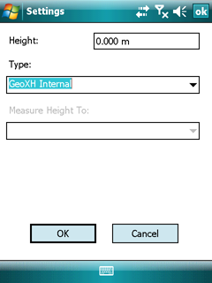
Height: the height of the antenna above the ground
![]() Please, enter "0" on the GNSS Survey panel when using the Height parameter on the Trimble Antenna Settings panel, anyway the measured height offsets with the default value of the Antenna height (on the GPS Survey dialog.)
Please, enter "0" on the GNSS Survey panel when using the Height parameter on the Trimble Antenna Settings panel, anyway the measured height offsets with the default value of the Antenna height (on the GPS Survey dialog.)
GNSS Survey Up/Down offset

Type: the type of antenna that is being used
Measure Height To: the physical point on the antenna that was used when measuring the height (the "measurement method")
Trimble postprocessing software uses "Measure Height To" information to compensate for the antenna height when displaying positional information, which gives more accurate elevation readings. For example, if an antenna height of 2.0 meters is specified, the postprocessing software automatically subtracts 2.0 meters from all GPS position and feature elevations, and displays the true ground elevation rather than the elevation at the antenna.
DigiTerra Explorer determines the list of available antennas and measurement methods. If the application is connected to a GPS receiver, only the antenna types supported by the connected receiver are shown. If the application is not connected to a GPS receiver, all antenna types are shown.
When the user clicks the OK button, the new antenna settings are applied. If an SSF file is open, an SSF Survey Station record is also written. The Survey Station record allows the postprocessing software to determine the antenna settings, and to apply the appropriate offset to all subsequent elevations in the file.