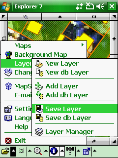
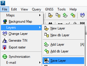
1.This command is accessible in the File menu > Layers sub-menu with the ![]() Save Layer button.
Save Layer button.
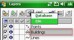
2.On the Layer Manager: tap on the ![]() Layer Export button > and select the File option in the pop-up menu.
Layer Export button > and select the File option in the pop-up menu.
Accessing to the Save Layer command in the menu
Accessing to the Save Layer command in the Desktop version
Accessing to the Save Layer command in the Layer Manager
![]() Save Layer
Save Layer
Opens the Save as file panel to export the active layer with another file name or into another file format.
![]() Active layer: Selected grayed layer on the Layer Manager
Active layer: Selected grayed layer on the Layer Manager
![]() In case of exporting a multi feature layer DigiTerra Explorer is able to save each feature types separately.
In case of exporting a multi feature layer DigiTerra Explorer is able to save each feature types separately.
Supported formats:
- Vector: BNA, CRD, DAT, DGN, DXF, MAP, MIF, SHP, ZIP
- Raster: JPG - 15% compression (85% quality) as default. The compression scale cannot be changed. PNG
- Table: DBF, TAB, TXT
|
Basic |
Advanced |
Professional |
Availability of the "Save Layer" command in different editions |
|
|
|
|
Basic |
Advanced |
Professional |
Supported vector formats with the Save Layer command |
|||
BNA - Atlas GIS |
|
|
|
CRD - Coordinates (point) |
|
|
|
DAT - Coordinates (shape) |
|
|
|
DGN - Microstation |
|
|
|
DXF - Autodesk |
|
|
|
MAP - DigiTerra |
|
|
|
MIF - Mapinfo Interchange |
|
|
|
SHP - ESRI Shape |
|
|
|
ZIP - Zipped ESRI Shape |
|
|
|
Supported tabular / text formats with the Save Layer command |
|||
DBF - dBase |
|
|
|
TAB - DigiTerra |
|
|
|
TXT - Text files |
|
|
|
Supported raster formats with the Save Layer command |
|||
JPG - JPEG file |
|
|
|
PNG - Portable Network Graphics |
|
|
|