Opens the Field work panel. The FieldWork tool remains active until you deactivate it by tapping on the Stop button.
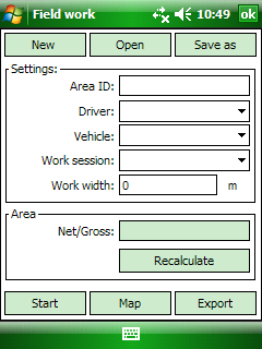
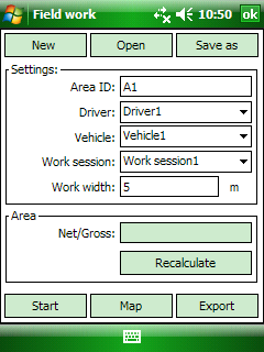
The Field work panel
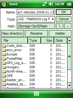
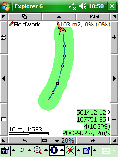
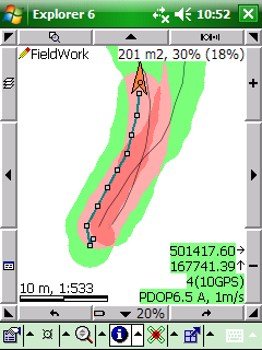
Save File panel; FieldWork in progress: displays the work width, the cultivated area in [m2] and the covered area in [%]
 zz
zz
New - Creates a new Field work GPS Tracklog (.LOG) file. Fill the parameters of the Settings: Area ID, Driver, Vehicle, Work session, Work width then tap on the Start button to open and save the log file by using the Save File panel.
Open - Opens the Open file File panel to open an existing Field work GPS Tracklog (.LOG) file.
Covers in a Field work Tracklog
Save as - Opens the Save as File panel to save as the current Field work GPS Tracklog (.LOG) as a new file with a different name.
Settings: attribute data for the current Field work GPS Tracklog file.
Area ID: Unique identification value of the current area where you work. Textual field, e.g. "parcel A3". Default value is empty. The software automatically increments the last value: 1, 2, 3, 4 ...; A1, A2, A3, A4 etc.
Driver: Name of the driver. Textual field, e.g. "John Smith".
Data Field name in the General.cdt code dictionary: FieldWorkDriver
Vehicle: Type of the vehicle. Textual field, e.g. "CAT Challenger 55".
Data Field name in the General.cdt code dictionary: FieldWorkMachine
Work session: Type of the current work session. Textual field, e.g. "plowing".
Data Field name in the General.cdt code dictionary: FieldWorkProcess
The following code sets can be used to the Driver, Vehicle and Work session setting parameters by enabling the default Gereal.cdt code dictionary on the Settings > Record tab. The default code sets can be edited in a simple text editor.
-------------------
FieldWork code sets
-------------------
# FieldWorkDriver
1 Driver-1
2 Driver-2
3 Driver-3
# FieldWorkMachine
1 Vehicle-1
2 Vehicle-2
3 Vehicle-3
# FieldWorkProcess
1 Work session-1
2 Work session-2
3 Work session-3
Work width: Path width in meter. Default value is 5 m.
Area:
Net/Gross: The calculated net/gross covered (cultivated) area in current area unit, that calculated by work width.
Recalculate - Recalculates the net/gross value of the covered area.
Start - Opens and save the log file by using the Save File panel. / Starts logging the current GPS positions continuously in the selected Field work GPS Tracklog file.
Map - Switches to the map view to display the current Field work GPS Tracklog file on the map.
Export - Calculates the covers between paths of the Field work GPS Tracklog and stores the results of the Cover Analysis in a TIFF raster layer in the same directory with the current Field work GPS Tracklog file.
|
Basic |
Advanced |
Professional |
Availability of the "FieldWork" tool in different editions |
|
|
|