The Record tab contains the following controls:
The Record tab
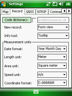
Code dictionary - Displays the PATH to the code dictionary that is used in the current map project. There is a default code dictionary in DigiTerra Explorer for every newly created mapping projects called General.cdt that you can use globally to store every code sets in it you are using instead of creating a new code dictionary file next to the map project. The left button opens the Code dictionary file panel to change the code dictionary you are using in the mapping project.
The default code dictionary file, General.cdt is unchecked. That means it is not in use. So if you want to use it in your map project tick the check-box before the PATH and DigiTerra Explorer will immediately use it. ie the new codes and code sets will be added into this file and the attributes display based on the code dictionary if there is a reference to a given code set in the data field name.
Path to the default code dictionary:
Desktop version: |
$DOCUMENTS\DigiTerra Explorer\Maps\General.cdt |
Mobile version: |
$SDCARD\Maps\General.cdt |
|
Basic |
Advanced |
Professional |
Availability of the "Code dictionary" feature in different editions |
|
|
|
![]() The path of the project's code dictionary file stored in the DigiTerra Explorer Map project file (.EXP). If you are using separate code dictionary in the project DigiTerra Explorer saves it next to the project file once you have added the first code set to a data field and closed the Record panel.
The path of the project's code dictionary file stored in the DigiTerra Explorer Map project file (.EXP). If you are using separate code dictionary in the project DigiTerra Explorer saves it next to the project file once you have added the first code set to a data field and closed the Record panel.
New record: Once the geometry capture of a new feature finished DigiTerra Explorer proceeds to attribute data capture and opens a panel with the attributes automatically.
The default panel is the Form view, that can be modified as:
No panel: Does not appear the dialog after recording geometry
Form view: Opens the Form view panel
List view: Opens the Record panel = List view
Tree view: Opens the Tree view panel. Useful when working with related attribute tables.
Info tool: Controls the operation of the ![]() Identify command.
Identify command.
The default option is the Tooltip, that can be modified as:
●Tooltip: the queried attributes display as tooltip on the map view
●Form view: the queried attributes display in the Form view panel
●List view: the queried attributes display in the Record panel = List view
●Tree view: the queried attributes display in the Tree view panel
Measurement units: You can choose the date format, length, area, speed unit and the coordinate format for degrees from drop-down lists as:
Date format
oYear Month Day (default)
●Month Day Year
●Day Month Year
Length unit
oMeter (default)
●Hectometer
●Kilometer
●Millimeter
●Centimeter
●Decimeter
●Inch
●Feet
●Feet (Clarke)
●Feet (Gold Coast)
●Feet (Sears)
●Feet (US)
●Yard
●Yard (Indian 1937)
●Yard (Indian)
●Yard (Sears)
●Fathom (1.8288 m)
●Fathom (Wien) (1.89m)
●Mile
●Nautical mile
Area unit
oSquare meter (default)
●Acre
●Are
●Hold
●Hectare
●Square millimeter
●Square centimeter
●Square decimeter
●Square inch
●Square kilometer
●Square foot
●Square yard
●Square fathom
●Square fathom (Wien)
●Square mile
●Square nautical mile
Speed unit
om/s (default)
●km/h
●f/s
●mph
●knot
Coordinate format
oD.ddddddd (default)
●D-M.mmmmm
●D-M-S.sss
●D.ddddddd°
●D°M.mmmmm
●D°M'S.sss
![]() These settings above are used in conjunction with the Creation time, GNSS Time, Area (custom), Perimeter (custom), Length (custom), Distance to last object (custom), Speed (custom), Latitude, Longitude data field default values on the Data field panel.
These settings above are used in conjunction with the Creation time, GNSS Time, Area (custom), Perimeter (custom), Length (custom), Distance to last object (custom), Speed (custom), Latitude, Longitude data field default values on the Data field panel.
![]() The map display unit is metric in the software. The default map unit is meter.
The map display unit is metric in the software. The default map unit is meter.