The Logger tab contains the following controls:
![]() Please note that the GNSS logfile button inactive in the trial edition.
Please note that the GNSS logfile button inactive in the trial edition.
|
Basic |
Advanced |
Professional |
Availability of the "Logger" tab in different editions |
|
|
|
The Logger tab
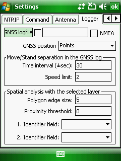
GNSS log: - You can save the projected GPS coordinates into a GPS tracklog file when the GPS active. Tap on the GPS log: button to set the path of the GPS tracklog file. The GPS logfile is turned off as default.
NMEA: Stores NMEA 0183 sentences in the selected GPS tracklog file when the GPS active. The default is unchecked.
GNSS position: Sets the type of geometry for processing of last added GPS tracklog file.
●Points: Creates points from every GPS position with ID, Date data fields.
●Lines: Creates lines between GPS positions with ID, Date, Length, Speed data fields.
●Polyline: Connects the GPS positions and create one polyline from it. Data fields are: Label, Date, Length, Area.
●Polygon: Connects the GPS positions and create one polygon from it. Data fields are: Label, Date, Length, Area.
Move/Stand separation in the GNSS log:
Determination of standing status for GPS log statistics.
Time interval (±sec): Set the time interval to select nearest points for speed calculation. It must be larger than the sampling frequency in the GPS tracklog file! The default time interval is ±5 sec.
Speed limit (km/hour): Set the limit to delineate the standing (less) or movement (more). The default speed limit is 2 km/hour.
Spatial analysis with the overlay layer:
Connecting GPS positions to polygons or nearest vector feature:
Polygon edge size (m): The program does not connect those positions to the area, where the distance between the outline of the area and the position is closer than the defined polygon edge size. The default edge is 5 m wide.
Proximity threshold (m): The minimum distance where the algorithm will interpret the current position of the GPS tracklog as nearest position. The default proximity threshold is 0 m.
1. Identifier field: Select the data field to identify the connected feature in the Feature field of the GPS log statistics. Default value is nothing.
2. Identifier field: Select an other data field to identify the connected feature in the Feature field of the GPS log statistics. Default value is nothing.