The  Startup command is accessible in the File menu, or by clicking on the Startup button in the toolbar (Desktop version).
Opens the Startup options panel that has two parts: the Main screen and the Settings area.
The following video tutorial explains the Startup options panel usage in detail:

Using the Startup options panel
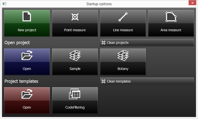
Startup options: Main screen
Startup options - Mobile version
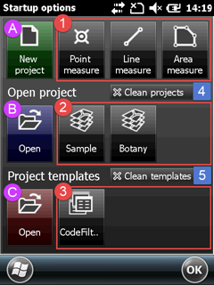
A - New project
Scrolls the Startup options panel to the Settings area to specify the project parameters and creates a new mapping project without layers. Default file format: .EXP that can be changed to any other supported map and mapping project formats when saving the project.
B - Open project
Opens the Open project File panel to open a Project
C - Project templates
Opens the Open Template File panel to open a Project template then scrolls the Startup options panel to the Settings area to specify the project parameters. Default file format: .EXP that can be changed to any other supported map and mapping project formats when saving the project.
1 - Quick measure functions
Scrolls the Startup options panel to the Settings area to specify the project parameters and creates a new mapping project with a point, line or polygon feature layer. Then opens the GNSS Surveying panel.
2 - Recent projects
Displays the three most recently opened projects. Tap any one of these to close the current project and open the selected one.
3 - Recent project templates
Displays the three most recently opened project templates. Tap any one of these to create a new mapping project using the selected project template.
4 - Clean projects
Removes the recent projects from the Startup options panel and the Recent Projects sub-menu
5 - Clean templates
Removes the recent project templates from the Startup options panel
|
Startup options: Settings
The Settings area of the Startup options panel displays automatically when using the following options on the panel:
oNew project
oQuick project
oProject templates
![]() Please note, that this is a scrollable panel. So when you can't see the controls at the bottom just drag the panel and scroll down.
Please note, that this is a scrollable panel. So when you can't see the controls at the bottom just drag the panel and scroll down.
Startup options > Settings - Mobile version
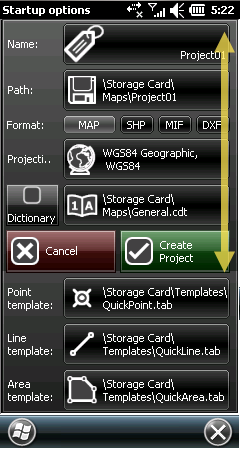
●Name - Displays the Project name. It can be edited on the Startup options Input panel by tapping/clicking on the path. The project file format is DigiTerra Explorer Map (.EXP)
Naming conventions:
oDefault is 'Project01'
oThe number at the and of the project name automatically increments
oAutomatically renames the project when trying to use the same project name to an existing project
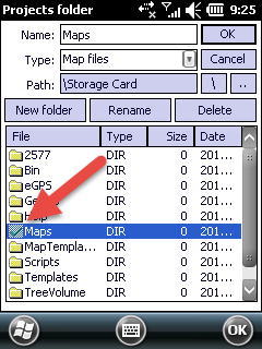
●Path - Displays the target directory where the project file will be saved. It can be modified by tapping/clicking on the name of the project.
Modifying the project folder:
Modifying the project folder - Mobile version
Modifying the project folder - Desktop version
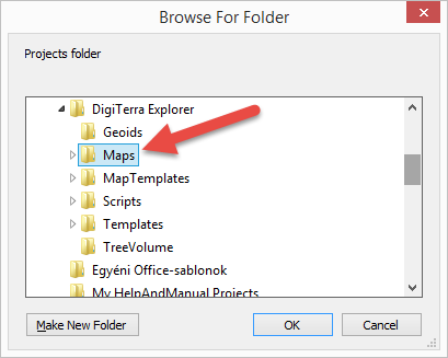
Default Path:
Desktop version: |
$DOCUMENTS\DigiTerra Explorer\Maps |
Mobile version: |
$SDCARD\Maps |
●Format - Specifies the output vector layer format to the Quick measure and Project template functions. It also specifies the default vector layer format when creating a new layer. The selected output format is grayed, the default is MAP - DigiTerra.
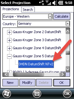
●Projection - Specifies the projection to the New project and Quick measure functions. The projection cannot be changed when using a Project template.
Modifying the projection:
Tap on/ click on the projection button to open the Select Projection panel and select a projection.
Selected projection
●Dictionary - Enables to use a global code dictionary to each project when checked. Default is unchecked, in this case the code dictionary stores next to the project file.
●Cancel - Cancels changes that has been made on the Startup options > Settings area and the panel scrolls back to the Startup options > Main screen.
●Create Project - Creates the project.
Attribute table templates to the Quick measure functions
●Point template - Displays the path to the current Point template file. The default is QuickPoint.tab.
●Line template - Displays the path to the current path of the Line template file. The default is QuickLine.tab.
●Area template - Displays the path to the Area template file. The default is QuickArea.tab.
Modifying the template:
Tap on/ click on the projection button to open the file panel to select a different template file.
![]() The QuickPoint.tab attribute table template can be used when working in a local projection system. In case of using global geographical LAT, LON coordinates please use the QuickPointWGS.tab template file.
The QuickPoint.tab attribute table template can be used when working in a local projection system. In case of using global geographical LAT, LON coordinates please use the QuickPointWGS.tab template file.
Templates Path:
Desktop version: |
$DOCUMENTS\DigiTerra Explorer\Templates |
Mobile version: |
$SDCARD\Templates |