Source: Raster layer |
  
|
Source: Raster layer |
|
The Source panel is used to configure some options that are specific to each layer in your map. You can access the Source panel by tapping the Source button in the Layers panel.
Open the Source panel to the selected raster layer
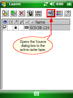
The Raster - Source panel to a raster layer
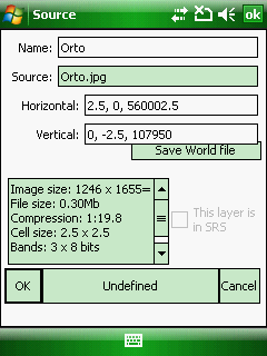
Name: The layer's name can be edited which will be displayed in the Layers panel. The default name of the layer is equal with the Source name.
Source: Displays the data source of the layer. DigiTerra Explorer stores relative path to the DigiTerra Explorer Map file (.EXP).
Georeferencing data: Can be edited by manually or with the raster orientation tool.
Horizontal: horizontal components of the georeferencing
1, 0, 786000
1: easting component of the pixel's x coordinate
0: easting component of the pixel's y coordinate
78600: easting offset (number of columns(x))
Vertical: vertical components of the georeferencing
0, -1, 156000
0: northing component of the pixel's x coordinate
-1: northing component of the pixel's y coordinate
156000: northing offset (number of rows(y))
Save World file: Saves the world file to the active raster layer based on the horizontal and vertical parameters of the raster layer. (A world file is a plain text computer data file used by geographic information systems to georeference raster map images.)
The generic meaning of world file parameters are:
Line 1: A: pixel size in the x-direction in map units/pixel
Line 2: D: rotation about y-axis
Line 3: B: rotation about x-axis
Line 4: E: pixel size in the y-direction in map units, almost always negative[3]
Line 5: C: x-coordinate of the center of the upper left pixel
Line 6: F: y-coordinate of the center of the upper left pixel
![]() You will find more information about the world file here: http://en.wikipedia.org/wiki/World_file
You will find more information about the world file here: http://en.wikipedia.org/wiki/World_file
Raster information: Displays the uncompressed image size (number of columns(x) and rows(y) of pixels), the compressed file size, compression rate, cell size (x,y) in meter and the number of bands with pixel depth/bit depth.
This layer is in SRS: Active only when the .dtproj file exists next to the layer. Please not that the .dtproj file will be removed when you uncheck this option.
OK - Saves the modification you have made on this panel and closes the panel.
Undefined - Opens the Select Projection dialog to set the known projection of the layer then displays the selected projection on this button. When adding a new layer to the map view DigiTerra Explorer assumes that its spatial reference system (SRS) is identical with the map view's SRS. When you select the known SRS to the layer on this panel DigiTerra Explorer on-the-fly transforms it into the map view's SRS and writes a .dtproj file next to the layer file. When the .dtproj file exists next to the layer it is Identified and you can see its projection parameters on this button.
Cancel - Closes the Source panel
![]() The source settings of the raster layers can be stored in the DigiTerra Explorer Map file (.EXP) or DigiTerra Map Pack file (.DMP) formats.
The source settings of the raster layers can be stored in the DigiTerra Explorer Map file (.EXP) or DigiTerra Map Pack file (.DMP) formats.