Buttons |
  
|
Buttons |
|
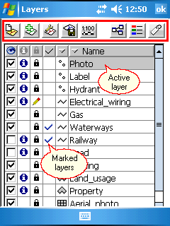
The Layers panel contains the following buttons:
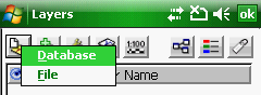
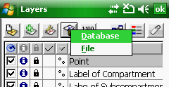
Opens a pop-up menu with the following options:
oDatabase: Opens the New db Layer panel to create a new geodatabase layer
oFile: Opens the Create layer file panel to create a new vector layer
New Layer - pop-up menu
More details about the relevant commands to this button can be found in the Layers sub-menu topic.
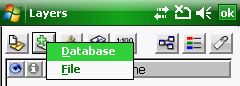
Opens a pop-up menu with the following options:
oDatabase: Opens the Add db Layer panel to add a geodatabase layer to the map view
oFile: Opens the Append layer panel file to add one or more layers to the map view
Add Layer - pop-up menu
More details about the relevant commands to this button can be found in the Layers sub-menu topic.
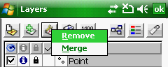
Opens a pop-up menu with the following options:
oRemove: Removes selected layers from the list
oMerge: Merges selected layers from the list. The merged layers can be saved into a new vector layer file.
Layer operations - pop-up menu
![]() Only the selected vector layers can be merged into MAP, DGN, DXF and MIF multi feature vector format: more than one feature type i.e. point, line and polygon within one layer
Only the selected vector layers can be merged into MAP, DGN, DXF and MIF multi feature vector format: more than one feature type i.e. point, line and polygon within one layer
Opens a pop-up menu with the following options:
oDatabase: Opens the Save db Layer panel to save (export) the active layer as a geodatabase layer
oFile: Opens the Save as file panel file to export the active layer into another file format or to save it with a different new name.
Add Layer - pop-up menu
More details about the relevant commands to this button can be found in the Layers sub-menu topic.
Opens the Scale panel. Sets the display scale range of the layers.
Opens different Source paneles by data source type as:
oVector layers, text and tabular files
to display and edit the properties of the data source.
![]() Layer classification, edit classes
Layer classification, edit classes
Opens different paneles by data source type as:
oVector layers --> Classes panel. The Classes panel lists all the thematic classes to the active DigiTerra Explorer vector layer as well as the symbology defined for the layer.
oRaster layers --> Raster Options panel
oTIN layers --> DEM Options panel
Opens the Labels panel. Labels a vector layer with the contents of the selected attribute field. Sets label properties.