New db Layer |
  
|
New db Layer |
|
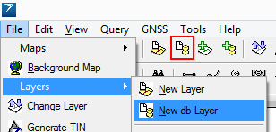
1.This command is accessible in the File menu > Layers sub-menu with the ![]() button and in the toolbar (Desktop version).
button and in the toolbar (Desktop version).
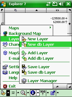
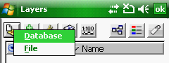
2.On the Layer Manager: tap on the ![]() New db Layer button > and select the Database option in the pop-up menu.
New db Layer button > and select the Database option in the pop-up menu.
Accessing to the New db Layer command in the menu
Accessing to the New db Layer command in the Desktop version
Accessing to the New db Layer command in the Layer Manager
![]() New db Layer
New db Layer
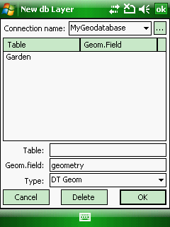
Opens the New db Layer panel to create a new (empty) geodatabase layer by entering the Table name. The New db Layer dialog allows to create a new (empty) layer into an SQLite DB3 geodatabase.
Supported geodatabase: DB3 - SQLite version 3
![]() Please have a look at this topic: Open db to learn how to create a new geodatabase to store the New database layer. If you want to use an existing geodatabase to store the New database layer follow the description at the bottom of this this topic: Database connection.
Please have a look at this topic: Open db to learn how to create a new geodatabase to store the New database layer. If you want to use an existing geodatabase to store the New database layer follow the description at the bottom of this this topic: Database connection.
![]() Once you have entered the Table name (it is the database layer name that appears on the Layer Manager) the New layer dialog appears even when working with file-based vector feature layers.
Once you have entered the Table name (it is the database layer name that appears on the Layer Manager) the New layer dialog appears even when working with file-based vector feature layers.
New db Layer panel
New db layer panel - inactive
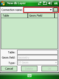
![]() If the New db Layer inactive select an existing connection from the Connection name combo box or add a new database connection to the combo box with the
If the New db Layer inactive select an existing connection from the Connection name combo box or add a new database connection to the combo box with the ![]() button.
button.
Connection name: Lists the connections in a drop-down list, that can be created on the Database connection dialog box to SQLite DB3 geodatabase files. A connection needs to be selected from the list to display its table(s) in the SQL table list below.
![]() - Opens the Database connection panel to manage connections with geodatabases
- Opens the Database connection panel to manage connections with geodatabases
SQL table list: Lists the SQL tables of the geodatabase. Tap on a list item to select an SQL table for deletion.
Table: Enter the name of the SQL table. This text box is empty as default.
Geom. field: Enter the name of the SQL field name that stores the geometry. The default name is geometry.
Type: Select a geometry type if you want to store to the vector geometry in the geodatabase.
●DT Geom: DigiTerra Binary Geometry data field type. Solid, encrypted data field format that can be only read by DigiTerra Explorer 7. Default geometry format.
●WKT: Well-known text (WKT) is a text markup language for representing vector geometry objects on a map, more details: http://en.wikipedia.org/wiki/Well-known_text
●WKB: Well-known binary (WKB). Solid data field format, more details: http://en.wikipedia.org/wiki/Well-known_text#Well-known_binary
Cancel - Closes the New db Layer panel
Delete - Deletes the selected SQL table from the geodatabase
OK - Creates the new database layer into the geodatabase
|
Basic |
Advanced |
Professional |
Availability of the "New db Layer" command in different editions |
|
|
|