Raster orientation |
  
|
Raster orientation |
|
You can modify the georeference data of the current raster image by using affine (1st order) polynomial transformation on-the-fly.
Tap / Left click on the map: designates/deletes control point on the map.
Drag: modifies the real position of the point.
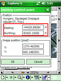
Tap and Hold / Right click on the control point: enter coordinates to the existing control point.
The Raster orientation remains active for georeferencing until another tool is activated.
When you georeference a raster image, you define its location using map coordinates in the selected coordinate system of the DigiTerra Explorer map. Georeferenced raster data allows it to be viewed, with other geographic data.
General steps for georeferencing a raster image are:
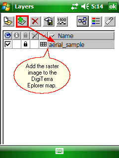
1.Add the raster image that you want to align with your projected data to the map view.
Add the raster image to the map
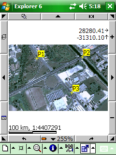
2.Add control points (maximum three control points can be used) and link them as known raster image positions to known positions in map coordinates.
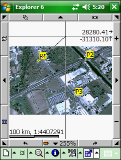
Link a control point to a known position by dragging
Link a control point to a known position by entering the map coordinates
3.Save the georeferencing information into the DigiTerra Explorer Map file (.EXP), or save them into a World file when you’re satisfied with the alignment (also referred to as registration).
Aligning the raster image with control points
Generally, you will georeference your raster image using existing spatial data (target data), such as a vector feature class, that resides in the desired map coordinate system. The process involves identifying three control points (known x,y coordinates) that link locations on the raster image with locations in the spatially referenced data (target data). Control points are locations that can be accurately identified on the raster dataset and in real-world coordinates. There are many different types of features that can be used as identifiable locations, such as road or stream intersections, the mouth of a stream, rock outcrops, the end of a jetty of land, the corner of an established field, street corners, or the intersection of two hedgerows.
![]() The modified georeferenced data can be stored to each image in the DigiTerra Explorer Map file (.EXP) format or can be saved to the active raster layer as a World file.
The modified georeferenced data can be stored to each image in the DigiTerra Explorer Map file (.EXP) format or can be saved to the active raster layer as a World file.