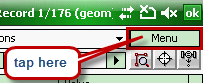
This menu is accessible from the Record panel when tapping/click on the [Menu] button in the top right corner:
|
Opens the New data field panel to add a new data field to the current attribute table. Equivalent with the [+] button on the Record panel at the bottom |
Adds a new record to the current attribute table. It can be used only when working with a data table without geometry in DBF, TAB, TXT file formats |
|
Deletes the current record with its geometry |
|
Deletes all or only the filtered records. This change cannot be undone! |
|
Opens the Filter panel to filter attribute records |
|
Opens the Sort panel to sort attribute records |
|
Switches the Record panel to List view. The default view is List view. |
|
Switches the Record panel to Tree view. It is useful when working with linked attribute tables. |
|
Opens the Geometry panel to display properties of the current attribute record's feature |
|
Displays the linked feature of the selected record on the map |
|
Activates the Target tool and sets the Target position to the selected feature of the record, equivalent with the Target button on the Record panel |
|
Activates the GNSS resurveying function, equivalent with the GNSS resurveying button on the Record panel |
|
Copies all content of the current table or only the filtered records to the clipboard |
|
Opens the Datatable export file panel to export the content of the attribute table into different file formats: ANL, GRN, TXT, CSV |
|
Opens the Field statistics panel |
|
Opens the Print Report panel to print the content of the current table or the filtered records. Available in the Desktop version only. |
|
Opens the Print Point Report panel to print an area report with a map attachment to the active record. Available in the Desktop version only. |
|
Opens the Print Area Report panel to print an area report with a map attachment to the active record. Available in the Desktop version only. |
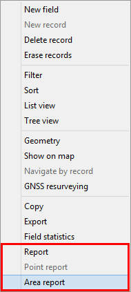
![]() Please note that the Point report and Area report options in the menu are printing related functions. The "Point report" disabled when the current data table is a polygon or line feature layer's attribute table. The "Area report" will be disabled when the current data table is a point or line feature layer's attribute table.
Please note that the Point report and Area report options in the menu are printing related functions. The "Point report" disabled when the current data table is a polygon or line feature layer's attribute table. The "Area report" will be disabled when the current data table is a point or line feature layer's attribute table.